OsmAnd is a navigation application that allows you to use maps wherever you are without using the Internet. This open source application uses OSM map data. lays routes with points and POIs, automatically recalculates the route in case of deviation, writes the current speed and estimated time of arrival, saves tracks.

The map can be rotated by movement, automatic scaling depending on the speed is supported. Supported options for movement by car, by bike, on foot. There is voice guidance, incl. and in Russian. The standard controls of the Android OS are used, the program is closed by the “back” button, pinch-to-zoom is supported. When the program is running, the phone does not automatically turn off the screen. Can receive traffic information from Yandex. A feature of the program is the online laying of routes through the services yournavigation.org and cloudmade.com. Directly in the program, you can also lay a small route. Necessary maps can be pre-loaded via Wi-Fi networks.
Possibilities:

- work with vector and raster maps without Internet access (to do this, you must first save the maps to the device’s memory card);
- loading vector and raster maps from the application itself;
- availability of compact vector maps for all countries of the world;
- loading of an arbitrary area for raster maps;
- displaying additional information on the map, such as GPX or navigation routes, points of interest (POIs), favorite locations, elevation lines, public transport stops; overlay additional maps with adjustable transparency;
- search for addresses and objects (POI) without Internet access;
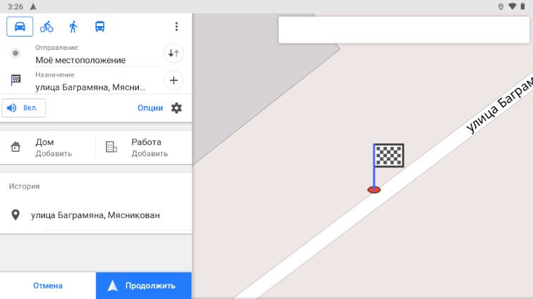
- laying routes for any distance using Internet services;
- laying routes for medium distances without Internet access;
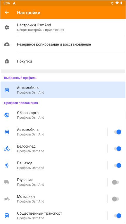
- car, bike and pedestrian modes with the following features: — automatic switching to day/night map rendering mode;
- changing the scale of the map depending on the speed;
- rotation of the map according to the compass or direction of movement;
- using voice commands (reproduced by recorded or generated voices) when moving along a route;
- speed warnings.

List of supported countries:
Afghanistan, Albania, Algeria, Andorra, Angola, Anguilla, Antigua and Barbuda, Argentina, Armenia, Aruba, Australia, Austria, Azerbaijan, Bahamas, Bahrain, Bangladesh, Barbados, Belarus, Belgium, Belize, Benin, Bermuda, Bhutan, Bolivia, Bonaire, Bosnia and Herzegovina, Botswana, Brazil, British Virgin Islands, Brunei, Bulgaria, Burkina Faso, Burundi, Cambodia, Cameroon, Canada, Cape Verde, Central African Republic, Chad, Chile, China, Colombia, Comoros, Congo, Costa Rica, Ivory Coast, Croatia, Cuba, Curacao, Cyprus, Czech Republic, Denmark, Djibouti, Dominica, Dominican Republic, Ecuador, Egypt, El Salvador, Equatorial Guinea, Eritrea, Estonia, Ethiopia, Fiji, Finland, France , French Guiana, French Polynesia, Gabon, Gambia, Georgia, Germany, Ghana, Gibraltar, Greece, Greenland, Grenada, Guadeloupe, Guam,Guatemala, Guernsey, Guinea, Guinea-Bissau, Guyana, Haiti, Vatican City, Honduras, Hong Kong, Hungary, Iceland, India, Indonesia, Iran, Iraq, Ireland, Isle of Man, Israel, Italy, Jamaica, Japan, Jersey, Jordan, Kazakhstan , Kenya, Kiribati, North Korea and South Korea, Kuwait, Kyrgyzstan, Laos, Latvia, Lebanon, Lesotho, Liberia, Libya, Liechtenstein, Lithuania, Luxembourg, Macau, Macedonia, Madagascar, Malawi, Malaysia, Maldives, Mali, Malta, Martinique , Mauritania, Mauritius, Mayotte, Mexico, Micronesia, Moldova, Monaco, Mongolia, Montenegro, Montserrat, Morocco, Mozambique, Myanmar, Namibia, Nauru, Nepal, Netherlands, Netherlands Antilles, New Caledonia, New Zealand, Nicaragua, Niger, Nigeria , Norway, Oman, Pakistan, Palau, Palestinian Territory, Panama, Papua New Guinea, Paraguay, Peru, Philippines, Poland, Portugal, Puerto Rico, Qatar,Romania,Russia , Rwanda, Saint Barthelemy, Saint Helena, Saint Kitts and Nevis, Saint Lucia, Saint Martin, Saint Pierre and Miquelon, Saint Vincent and the Grenadines, Samoa, San Marino, Saudi Arabia, Senegal, Serbia , Seychelles, Sierra Leone, Singapore, Slovakia, Slovenia, Somalia, South Africa, South Georgia, South Sudan, Spain, Sri Lanka, Sudan, Republic of Suriname, Swaziland, Sweden, Switzerland, Syria, Taiwan, Tajikistan, Tanzania, Thailand, East Timor, Togo, Tokelau, Tonga, Trinidad and Tobago, Tunisia, Turkey, Turkmenistan, Tuvalu, Uganda, Ukraine, United Arab Emirates, United Kingdom (UK), United States of America (USA), Uruguay, Uzbekistan, Vanuatu, Venezuela, Vietnam, Wallis and Futuna, Western Sahara, Yemen, Zambia, Zimbabwe.
Differences from the free version of OsmAnd:
• unlimited number of downloads
• availability of data from Wikipedia about objects on the map
• Improved “Tracks” menu in “Configure Map”
• Context menu now displays localized names for POI
• Added option to share route by link
• Added “Nautical miles/feet” unit of length
• Map orientation added new fixed mode
• Simplified start screen
• AFixed location position in split screen mode in Android Auto
• Added “Speed/Slope” graph for track analysis
• Android 13 moved app language selection to system settings
• Fixed issues with displaying Vegan places
OS: Android™ 6.0 and higher
Interface language: multilingual/Russian

Download OsmAnd+ Maps & GPS Offline 4.4.3 for ARM/ARM64/X86/X86-X64 CPU (328.6 MB):